Abstract
Situated in the southern regions of Iran and Pakistan, the Makran subduction zone is bound by the Zendan Fault to the west and the Chaman Fault to the east. This region, lying at the complex confluence of the Arabian, Eurasian, and Indian plates, features intricate structural geology and dynamic tectonic activities, characterized by intermediate to deep focus seismicity, where a most common type of faulting is dip-slip, tracing the down going slab of Oceanic plate. This study employs an inversion technique to decode subsurface information, analyzing Teleseismic P-waveforms and their tailing surface reflections, from seismic events between 1990 and 2018. We meticulously selected 67 events in Western Makran, discarding data compromised by various noise types. We relocated the depth and determined the focal mechanism solutions at the 67 shallows to intermediate earthquakes. Through the application of the Kikuchi and Kanamori method, modeling of Teleseismic P-wave and its tailing surface reflections were performed on filtered data to process Inversion mechanism. Our findings illuminate the seismic behavior along the Jiroft fault, revealing intermediate-depth seismic events that penetrate beyond the crustal thickness and extend into the upper mantle. These insights enhance our understanding of the fault dynamics and tectonic stress distribution in the region, contributing to the broader geological knowledge of the Makran subduction zone.
Keywords: Geology; Teleseismic P-waveforms; Earthquakes; Earth’s dynamic processes; Lagoonal environment; seismological science
Introduction
The study of earthquake mechanisms has evolved significantly over the late 20th century, with advancements in seismological science providing deeper insights into Earth’s dynamic processes. The decoding of seismic waves has become instrumental in unraveling mysteries surrounding source ruptures, subduction zones, and plate tectonics, thus enriching our understanding of fundamental geotectonic phenomena [1,2].
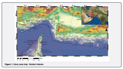
Located at the complex convergence of the Arabian, Eurasian, and Indian plates, the Makran subduction zone, spanning the southwestern part of Pakistan and southeastern Iran, is a region of significant geophysical interest Figure 1.
This area, bounded by the Zendan Fault in the west and the Chaman Fault in the east, has been an active subduction zone since the Late Cretaceous. The subduction of the oceanic Arabian plate beneath the Eurasian continental plate [3-7] which marks the closure of the Neo-Tethys Ocean, evident approximately 20 million years ago, and has continued to influence regional tectonic dynamics [8,9].
Makran's proximity to a triple junction, where these major plates (Eurasian, Indian and Arabian) intersect, adds another layer of complexity (Figure 2), [10]. This junction is a hotspot for seismic activity, including some of the largest recorded earthquakes in the region, such as the Mw 8.2 event in 1945 [11]. Despite these significant events, Western Makran often exhibits aseismic behavior, which has been attributed to its high sediment input and low taper, dampening the seismic potential typically expected from such geologically active regions [12].
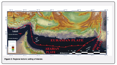
Accretionary wedge related to Makran is said to be World’s largest accretionary prism [6,13,14] and extends around 1000km, bounded between Minab-Zindan Fault System (MZFS) is a Dextral fault in Iran and Chaman-Ornach-Nal Fault System (COFS) is a Sinistral fault in Pakistan [7]. The growth of such large Accretionary wedge/prism is believed to be because of deposition and deformation of marine flysch deposit [15] as Makran Accretionary wedge has highest sediments input and highest incoming sediment thickness as well [6] and the wedge is progradation towards sea by trench fill sediments (Kopp et al., 2000).
Recent studies have proposed that the Makran region functions as a separate microplate, defined by distinctive seismic patterns and structural boundaries [5,16]. This characterization is crucial for understanding the seismic risks and geotectonic dynamics of the region, particularly in light of its development significance with projects like the Gwadar and Chabahar ports. Makran is typically a region bounded by Faults from almost all sides and is considered as scrappy part of the Neo-Tethys [5]. Towards west of Makran, it is bounded by of Right lateral MZFS strike-slip fault in Iran [6] and towards eastern side of Makran it has been bounded by Left lateral COFS strike-slip fault, [5]. In Western Makran it is bounded from North by Jiroft Fault (ophiolites) and extending eastwards, towards south this region is bounded by Makran Subduction Thrust in Oman trench which lies ahead of Murray Ridge, which was rifted, is NE-SW trending ridge System and marking the extreme North extension of the Owen Fracture Zone [17]. Currently, sea-floor spreading has a pace of 2mm/a [18], while Owen Fracture Zone (OFZ) is inferred as Transform marginal boundary between Arabian and Indian plates, was in South of OFZ Carlsberg Ridge is terminating in transform boundary [19,20].
Makran has been divided into four subparts from North to South, it extends cross-strike 400±600km from offshore Oman trench to Volcanic arc and ophiolites [13] on basis of Tectono-stratigraphy its divisions are as follow.
The uppermost or northern area of Makran (known as North Makran) is surrounded by the Quaternary deposits of Jaz Murian Depression (JMD) in the region of Iran (in North of Western Makran) and the equivalent Mashkel depression in Pakistan [21-23]. These deposits are mainly composed of metamorphic bodies, continental “terranes” and terrigenous turbidites [10,24] with their sedimentary cover [7]. Ophiolitic sequence, volcanic presence [25,26] imbricates in several lithologies found thrusting southwards on Bajgan-Durkan Complex [27] delineating lower marginal boundary of North Makran (Burg, 2018). Normal faults which are steeply dipping, marking contacts with JMD in Iran and Mashkel forearc basin in Pakistan, near Makran magmatic arcs Chaghi, Rah Kos [28]. Inner Makran mainly composed of marine deposits, lithologies containing sandstones, pelagic red limestones, radiolarian mudstone, shale and terrigenous turbidities, while having thrust sheets between Bashakerd Thrust at Northern part and towards southern part is marked by Ghasr Ghand Thrust [29,30].
Outer Makran lies between Ghasr Ghand Thrust GGT and Chah Khan thrust CKT have Marls, Calcareous sandstones, shales and deep marine turbiditic sequence, deep-sea fan [31,32]. Costal Makran lies among Thrusts Chah Khan thrust CKT towards North and at South current coastal line [33] transitional facies, marl, calcareous sandstones are dominated for several kilometers, Mudstone dominated sequence coarsening up, along with mollusc shells [32] gypsiferous mudstones having mud cracks showing Lagoonal environment in past. Younger successions consist of fluvial sediments and lateral thick beds of continental conglomerates [34].
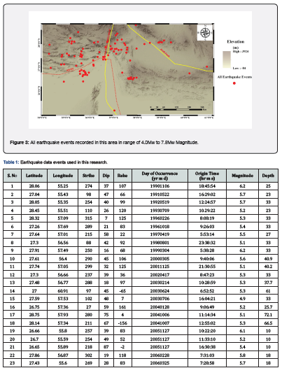
Figure 3, illustrates the spatial distribution of seismic events recorded in the Western Makran region, highlighting earthquake occurrences with magnitudes ranging from 4.0Mw to 7.8Mw. The map shows a dense cluster of seismicity aligned along major geological features, providing insights into the active tectonic processes in this area. These events are primarily concentrated along the MZFS and the Jiroft Fault, as delineated by the yellow lines. The distribution pattern suggests a significant level of tectonic activity along these fault zones, which are critical in accommodating the northward convergence of the Arabian plate into the Eurasian plate. MZFS, is a major strike-slip fault represents a significant tectonic boundary where stress accumulation and release occur, as evidenced by the clustering of seismic events along this line. The concentration of earthquakes along these faults highlights their role as major conduits for seismic energy release in the Western Makran region. The spatial distribution of these seismic events provides valuable information for assessing the seismic hazard associated with these faults, particularly in relation to the potential for larger earthquakes that can impact the densely populated regions nearby.
Figure 4, presents the spatial distribution of seismic events within the Western Makran region, illustrating both the depth and magnitude of these events in relation to significant tectonic boundaries. The color-coded circles represent the depth at which each earthquake occurred, while the size of each circle indicates the magnitude range of the event. The variation in earthquake depths and magnitudes across different parts of the fault zones can help infer the mechanical properties of the Earth's crust and mantle interactions in these regions.
Material and Methods
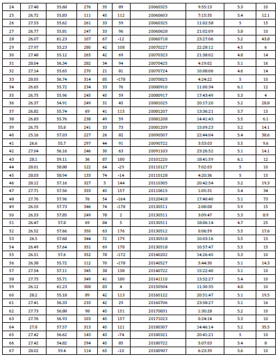
For this study, seismic data were acquired from the Seismic Monitoring Agency (IRIS), formatted in Time Series SEED Data format, which is particularly suited for handling high-resolution earthquake data (Goldstein and Snoke, 2005). Table 1presents a detailed catalog of seismic activities, comprising key parameters and attributes integral to our seismic analysis. Each listed event includes geographical coordinates (latitude and longitude), seismic orientations (strike, dip, rake), chronological data (date and time of occurrence), along with magnitude and depth.
To mitigate the impact of noise such as shallow mantle triplications, the epicentral distances of the recording stations were maintained between 30° and 90° for vertical components. This range helps in optimizing the signal-to-noise ratio (S/N) and ensuring the reliability of the seismic data interpretation. The earthquake catalog was enriched with detailed event characteristics from the Global Centroid Moment Tensor (GCMT) database [35]. This database provides comprehensive seismic moment tensors, which are crucial for understanding the source mechanisms of earthquakes.
The Seismic Analysis Code (SAC) software was utilized to process the seismic data. SAC tools enabled us to inspect the data meticulously, pick seismic phases accurately, and enhance S/R, which is pivotal for the detailed analysis of seismic events [36]. These processes ensure the extraction of meaningful seismic signals from the background noise, facilitating robust seismic interpretation.
The numerical method developed by [37] was employed for the direct inversion of complex Teleseismic body waves. This technique involved correlating observed P-waveforms with synthetic waveforms to decipher the subsurface seismic information accurately. The synthetic waveforms were generated using a layered velocity and density model based on CRUST1.0 [38]. This model incorporates five distinct layers, providing a detailed structural representation of the Earth's crust, which is essential for precise seismic wave simulation.
Results and Discussion
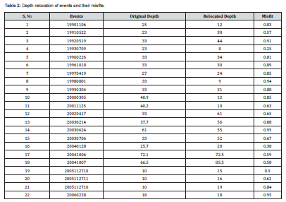
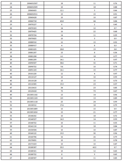
Our study's comprehensive analysis of seismic activity in Western Makran has employed advanced seismic inversion techniques to decode subsurface information. Through the application of MATLAB utilities and SAC software, we processed seismic waveform data to extract detailed focal mechanism solutions. These solutions are depicted in the "Beach Ball" diagrams which provide a visual interpretation of stress orientations and fault movement at the moment of seismic events. The localization of seismic events is a critical step in our analysis. We utilized a software-based method incorporating the CRUST1.0 global crustal model, which provides a 1D velocity model at 1x1 degrees resolution. This approach, integrated with MATLAB’s built-in scripts, allowed for precise depth relocation and correlation with synthetic waveform data. The resulting alignments and misfits between observed and synthetic data significantly aid in validating the seismic mechanisms inferred from our analysis. Table 2 delineates the outcomes of depth relocation analyses, presenting a comparison of original and relocated depths for selected seismic events alongside the associated misfit values.
Event 1993 07 09 (Figure 5): This event occurred at a depth of 39.0km and showed significant waveform alignments at depths ranging from 38 to 40km, with a minimum misfit observed at 38km. The focal mechanism solution indicates a predominantly dip-slip movement, suggesting a vertically oriented stress regime likely driven by subduction dynamics.
Event 2004 01 28 (Figure 6): Recorded at a depth of 20.0km, this event displayed optimal waveform matching at depths from 10 to 30km. The focal mechanism points to complex faulting with a mix of strike-slip and dip-slip components, reflective of the intricate tectonic interactions at shallower depths within the subduction zone.
Event 2014 07 22 (Figure 7): This shallower event at 11.0km depth presented waveform correlations extending slightly deeper, with best fits around 10 to 12km. The "Beach Ball" diagram suggests a significant strike-slip component, indicative of lateral tectonic movements adjacent to or within the fracture zones.
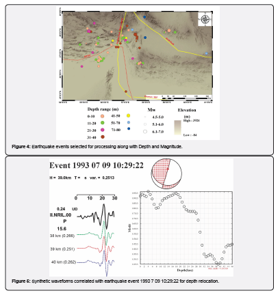
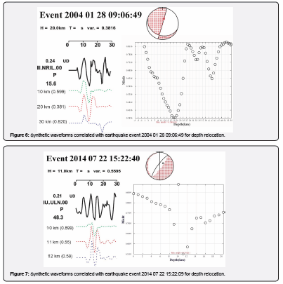
Figure 8, provides a comprehensive overview of the spatial distribution of seismic events within the Western Makran region, aligned along three strategic cross-sectional profiles: P1, P2, and P3. Each profile is designed to traverse key geological features and fault zones, offering insights into the depth, magnitude, and nature of seismic activity related to the complex tectonic framework of this area
Profile P1 starting from northeast to southwest, this profile captures seismic events across varying depths and magnitudes, illustrating the interaction between tectonic forces at the Eurasian and Arabian plate boundaries. The profile helps in understanding the vertical and lateral extent of seismicity associated with major fault systems, including the strike-slip and reverse fault movements that dominate this region Figure 9. This profile is strategically aligned perpendicular to the Makran subduction complex, offering a unique cross-sectional view of the subduction interface. The Moho shows a progressive descent from the continental side towards the oceanic side, which is characteristic of subduction zones where one tectonic plate slides beneath another.
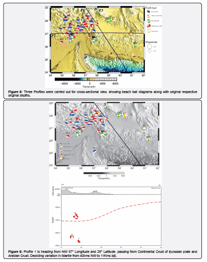
The focal mechanisms represented in the "Beach Ball" diagrams indicate a variety of faulting behaviors. The presence of reverse faults, oblique normal faults, and strike-slip faults in this profile illustrates the complex stress regime in this area. These faulting patterns are indicative of the tectonic forces at play, where the oceanic crust is being forced under the continental crust, generating significant seismic activity.
This profile is instrumental in understanding the interaction between the continental crust of the Eurasian plate and the oceanic crust of the Arabian plate. The red dashed line represents the Moho boundary, providing a critical marker for the transition between the crust and the mantle. Observations from this profile indicate a significant depth variation in the Moho, descending from approximately 41km in the continental region to about 11km in the oceanic region. This variation in Moho depth is essential for understanding the dynamics of subduction, as it suggests a steep angle of oceanic plate subduction beneath the continental plate, which is typical of active subduction zones. The cross-section shows a distinct pattern of earthquakes occurring along the subduction zone, where the Arabian oceanic plate is being forced under the Eurasian continental plate. The concentration of deeper and high-magnitude earthquakes near the Zendan Fault (as highlighted by the seismic events near the NW start of the profile) provides evidence of intense tectonic activity and stress accumulation within this region.
Events like the 5.1 magnitude earthquake at a depth of approximately 70km reflect deeper subduction processes, while shallower events may relate to crustal adjustments or sedimentary processes associated with the accretionary wedge.
The occurrence of deep earthquakes can be indicative of the temperature and mechanical strength of the subducting slab. Cooler, more brittle slabs are capable of sustaining the stresses needed to generate earthquakes at greater depths. At certain pressures and temperatures corresponding to depths around 70km and greater, the oceanic crust and upper mantle materials can undergo mineral phase changes that increase the density and may lead to stress accumulation and subsequent seismic events. At certain pressures and temperatures corresponding to depths around 70km and greater, the oceanic crust and upper mantle materials can undergo mineral phase changes that increase the density and may lead to stress accumulation and subsequent seismic events.
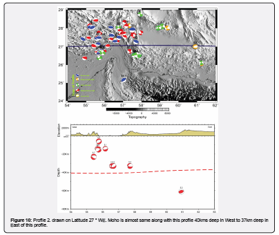
Profile P2 reveals a notable variation in the Moho depth, illustrating the transition from thicker continental crust to thinner oceanic crust as it moves from northwest to southeast. This profile extends from NW at 54° Longitude and 29° Latitude to SE at 69° Longitude and 22° Latitude, spanning a diverse range of topographical features from the elevated continental regions to the lower oceanic terrains Figure 10. The surface elevation profile underscores the transition from rugged, mountainous terrain to the smoother, oceanic seabed, highlighting the geological complexity of the Makran subduction zone. The detailed mapping of seismic events along this profile, particularly that penetrating the Moho and reaching into the mantle, offers insights into the ongoing subduction process. Depth changes in the Moho along this profile reflect the dynamics of subduction, with the depth decreasing from approximately 40km in the NW to almost 37km depths towards the SE.
Profile P3 The depicted seismic events, ranging from shallow to deep (up to 70km), align with both the MZFS and Jiroft faults. The distribution of these events indicates active faulting across a range of depths, with the Jiroft fault exhibiting significant deep seismicity that suggests penetration into the upper mantle Figure 11. This deep seismic activity could be indicative of crustal deformations that extend beyond the crust, emphasizing the dynamic nature of these fault zones.
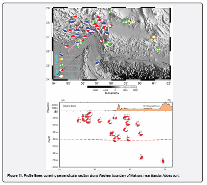
The Moho depth appears relatively uniform across this profile, with minor fluctuations indicating a stable but possibly thinning subduction zone beneath this part of the Makran.
The concentration of earthquakes along this profile, particularly near known fault zones, highlights regions of potential hazard and suggests that these faults are actively accommodating regional tectonic stresses. The presence of deep earthquakes near the Jiroft fault, often associated with a normal faulting mechanism, may suggest the existence of tensional forces at depth, which could be related to the complex dynamics of plate interactions in this area.
Conclusion
This study has systematically documented seismic events that transcend the traditional bounds of crustal thickness, revealing profound tectonic activity along the proposed margins of the Pakistan-Iran Makran Microplate (P-IMM). Notably, these events cluster around the Jiroft Fault, which delineates the northern boundary of the P-IMM adjacent to the Jaz Murian Depression. This fault's trajectory extends eastward into the heart of the Makran Accretionary Prism, with recorded seismicity reaching depths of 60 to 80km. Such profound depths of seismic activity underscore the complex and dynamic nature of this tectonic setting.
Additionally, the Zendan Fault in Iran and the Ornach–Nal Fault in Pakistan form the western and eastern peripheries of the P-IMM, respectively. The southern demarcation aligns with the subduction interface along the Arabian Plate at the Oman Trench. The presence of deep seismic events along these boundaries further supports the hypothesis of the P-IMM as a potentially isolated tectonic entity. This isolation is suggested by the distinct tectonic behaviors and the deep-reaching seismic events that effectively sever this microplate from the surrounding continental structures.
The implications of these findings are significant, suggesting that the P-IMM could represent a unique tectonic entity, distinguished by its deep sub-surface seismic activity and clearly demarcated fault lines that penetrate down to the Moho discontinuity. Such characteristics could indicate a degree of tectonic isolation or a distinct mechanical behavior from the adjoining Eurasian and Arabian plates.
The potential isolation of the P-IMM, if further substantiated, could have significant implications for regional tectonic models and earthquake hazard assessments in the Pakistan-Iran transboundary region. Given the active seismicity and the strategic tectonic setting, continued geophysical monitoring and detailed seismic profiling are recommended to better understand the fault mechanics and potential seismic risks. Such studies are essential for developing more accurate models of earthquake generation and propagation in this tectonically active region.
Statements and Declaration
Ethical Approval: This manuscript has not been published elsewhere in part or in entirety and is not under consideration by another journal. We have read and understood your journal’s policies, and we believe that neither the manuscript nor the study violates any of these. We have not submitted our manuscript to a preprint server before submitting it here.
References
- Banghar AR, Sykes LR (1969) Focal mechanisms of earthquakes in the Indian Ocean and adjacent regions. Journal of Geophysical Research 74(2): 632-649.
- Shimizu K, Yagi Y, Okuwaki R, Fukahata Y (2019) Development of an inversion method to extract information on fault geometry from teleseismic data. Geophysical Journal International 220(2): 1055-1065.
- Romano D, Matteucci F (2007) Contrasting copper evolution in ω Centauri and the Milky Way. Monthly Notices of the Royal Astronomical Society: Letters 378(1): L59-L63.
- DeMets C, Gordon RG, Argus DF (2010) Geologically current plate motions. Geophysical Journal International 181(1): 1-80.
- Siddiqui NK, Jadoon IAK (2012) Indo-Eurasian Plate collision and the evolution of Pak-Iran Makran Microplate, Pishin-Katawaz Fault Block and the Porali Trough, in Search and Discovery Article# 30265 (2013), PAPG/SPE Annual Technical Conference, 3–5 December 2012, Islamabad, Pakistan.
- Smith G, McNeill L, Henstock TJ, Bull J (2012) The structure and fault activity of the Makran accretionary prism. Journal of Geophysical Research: Solid Earth 117(B7).
- Burg JP (2018) Geology of the onshore Makran accretionary wedge: Synthesis and tectonic interpretation. Earth-Science Reviews 185: 1210-1231.
- Reilinger R, McClusky S, Vernant P, Lawrence S, Ergintav S, et al. (2006) GPS constraints on continental deformation in the Africa‐Arabia‐Eurasia continental collision zone and implications for the dynamics of plate interactions. Journal of Geophysical Research. Solid Earth 111.
- Barber DE, Stockli DF, Horton BK, Koshnaw RI (2018) Cenozoic Exhumation and Foreland Basin Evolution of the Zagros Orogen During the Arabia-Eurasia Collision, Western Iran. Tectonics 37(12): 4396-4420.
- Ellouz-Zimmermann N, Lallemant SJ, Castilla R, Mouchot N, Leturmy P, et al. (2007) Offshore frontal part of the Makran Accretionary prism: The Chamak survey (Pakistan). In: Thrust belts and foreland basins, Springer, pp. 351-366.
- Pacheco JF, Sykes LR (1992) Seismic moment catalog of large shallow earthquakes, 1900 to 1989. Bulletin of the Seismological Society of America 82(3): 1306-1349.
- Byrne DE, Davis DM, Sykes LR (1988) Loci and maximum size of thrust earthquakes and the mechanics of the shallow region of subduction zones. Tectonics 7(4): 833-857.
- Kopp C, Fruehn J, Flueh ER, Reichert C, Kukowski N, et al. (2000) Structure of the Makran subduction zone from wide-angle and reflection seismic data. Tectonophysics 329(1-4): 171-191.
- Gutscher MA, Westbrook GK (2009) Great earthquakes in slow-subduction, low-taper margins. In: Subduction Zone Geodynamics, Springer, pp. 119-133.
- Burg JP (2011) The Asia–Kohistan–India collision: review and discussion. In: Arc-continent collision. Springer, pp. 279-309.
- Abbasi MIH (2020) Is Makran a Separate Microplate? A Short Review. Malaysian Journal of Geosciences (MJG) 5(1): 1-5.
- Gaedicke C, Schlüter HU, Roeser HA, Prexl A, Schreckenberger B, et al. (2002) Origin of the northern Indus Fan and Murray Ridge, Northern Arabian Sea: interpretation from seismic and magnetic imaging. Tectonophysics 355(1-4): 127-143.
- DeMets C, Gordon RG, Argus DF, Stein S (1990) Current plate motions. Geophysical journal international 101(2): 425-478.
- Edwards RA, Minshull TA, White RS (2000) Extension across the Indian–Arabian plate boundary: the Murray Ridge. Geophysical Journal International 142(2): 461-477.
- Khan M, Liu Y, Farid A, Ahmed H (2019) Indications of uplift from seismic stratigraphy and backstripping of the well data in western Indus offshore Pakistan. Geological Journal 5(1): 553-570.
- McCall GJH (1985) Explanatory Text of the Minab Quadrangle Map, 1: 250,000. Geological Survey of Iran.
- Glennie KW, Clarke MWH, Boeuf MGA, Pilaar WFH, Reinhardt BM (1990) Inter-relationship of Makran-Oman Mountains belts of convergence. Geological Society, London, Special Publications 49: 773-786.
- Dolati A, Burg JP (2013) Preliminary fault analysis and paleostress evolution in the Makran Fold-and-Thrust Belt in Iran, in Lithosphere Dynamics and Sedimentary Basins: The Arabian Plate and Analogues, Springer, pp. 261-277.
- McCall GJH (1997) The geotectonic history of the Makran and adjacent areas of southern Iran. Journal of Asian Earth Sciences 15(6): 517-531.
- McCall GJH (2002) A summary of the geology of the Iranian Makran. Geological Society, London, Special Publications, 195: 147-204.
- Jafari MK, Babaie HA, Moslempour ME (2017) Mid-ocean-ridge to suprasubduction geochemical transition in the hypabyssal and extrusive sequences of major Upper Cretaceous ophiolites of Iran: Tectonic Evolution, Collision, and Seismicity of Southwest Asia. In Honor of Manuel Berberian’s Forty-Five Years of Research Contributions 525: 229.
- McCall GJH, Kidd RGW, Leggett JK (1982) Trench-Forearc Geology: Sedimentation and Tectonics on Modern and Ancient Active Plate Margins.
- Burg JP, Dolati A, Bernoulli D, Smit J (2013) Structural style of the Makran Tertiary accretionary complex in SE-Iran. In: Lithosphere dynamics and sedimentary basins: The Arabian Plate and analogues, Springer, pp. 239-259.
- McCall GJH, Eftekhar-Nezad J (1993) Explanatory Text of the Nikhshahr Quadrangle Map, 1: 250 000, L14. Geological Survey of Iran, Tehran.
- Haghipour N, Burg JP, Kober F, Zeilinger G, Ivy-Ochs S, et al. (2012) Rate of crustal shortening and non-Coulomb behaviour of an active accretionary wedge: The folded fluvial terraces in Makran (SE, Iran). Earth and Planetary Science Letters 355-356: 187-198.
- Harms JC, Cappel HN, Francis DC (1982) Geology and petroleum potential of the Makran Coast, Pakistan. Society of Petroleum Engineers.
- Dolati A (2010) Stratigraphy, structural geology and low-temperature thermochronology across the Makran accretionary wedge in Iran.
- Mohammadi A, Burg JP, Winkler W, Ruh J, von Quadt A (2016) Detrital zircon and provenance analysis of Late Cretaceous–Miocene onshore Iranian Makran strata: Implications for the tectonic setting. GSA Bulletin 128(9-10): 1481-1499.
- Haghipour N, Burg JP, Ivy-Ochs S, Hajdas I, Kubik P, et al. (2015) Correlation of fluvial terraces and temporal steady-state incision on the onshore Makran accretionary wedge in southeastern Iran: Insight from channel profiles and 10Be exposure dating of strath terraces. GSA Bulletin 127(3-4): 560-583.
- Ekström G, Nettles M, Dziewoński AM (2012) The global CMT project 2004–2010: Centroid-moment tensors for 13,017 earthquakes. Physics of the Earth and Planetary Interiors 200-201: 1-9.
- Goldstein P, Snoke A (2005) SAC availability for the IRIS community: Incorporated Research Institutions for Seismology Newsletter, v. 7.
- Kikuchi M, Kanamori H (1982) Inversion of complex body waves. Bulletin of the Seismological Society of America 72(2): 491-506.
- Laske G, Masters G, Ma Z, Pasyanos M (2013) Update on CRUST1. 0—A 1-degree global model of Earth’s crust. In: Geophys Res Abstr, EGU General Assembly Vienna, Austria, 15: 2658.


